



Read this guide inEnglishEspañolFrançais
120 beaches, updated daily · season 2026
Sargassum in the Riviera Maya:
the honest version
Every agent on this coast has an answer to the seaweed question and most of them are adjectives. Here is the live map instead, the season month by month, and what sargassum actually does to a rental projection, a resale and a maintenance fee. Read it once and you will know more about this coast than most people who already own here.
What the beaches look like
today, not last season
Beach conditions update daily. This page last reviewed September 2026.
One hundred and twenty beaches from Isla Contoy and Holbox down to Sian Ka’an, each with a coloured dot on a five-point condition scale. Click any beach to open its card with photographs and live cameras. The data is not ours and we do not edit it, which is the point.
Live sargassum data provided by Sargazo Watch, updated daily from visitor photographs and beach cameras. For the basin-wide picture, the University of South Florida Optical Oceanography Lab publishes a monthly satellite outlook for the Caribbean, and its high-resolution detection work is funded by NOAA. Neither source is ours and neither can be edited by us.
Why an outside map and not our own photo gallery. This is the most misrepresented subject on the coast: 2018 images and photographs from other countries still circulate as if they were taken this week. An independent record with dates is worth more than anything we could show you. Use it the way we use it: before a viewing trip, to pick which week you come, and during due diligence, to read the record of the specific beach you are considering. Click any beach on the map and it opens that beach’s own page on Sargazo Watch, where the full photographic record and the live cameras are, many more images than any page of ours could hold.
The internet looks worse
than the beach does
A single bad morning, photographed at the right angle, travels for years.
Images from 2018 still circulate as if they were taken last week, and photographs from other countries in the belt get captioned as Mexico. The subject is misrepresented in both directions: by the panic, and by the agent who swears it never reaches his beach. Neither one shows you a date.
That is why the map above is not ours. Look at the beach you care about, on the day you care about, on a record we cannot edit.
- What circulatesOne photograph, no date, no beach name, reposted every summer
- What is trueConditions change by beach and by week, and are recorded daily with dates
- What circulates“It never reaches our beach”, from the person selling you the unit
- What is trueCheck it yourself above, for the months you actually plan to be here
It has a calendar,
and the calendar is the whole story
Sargassum is seasonal, it varies year to year, and it is driven by currents and water temperature rather than by any single beach doing something wrong. Broadly, the coast reads like this. Treat it as the shape of a normal year, then check the map for the year you are in.
The high season for a reason. Beaches are typically at their cleanest and this is when almost every buyer sees the coast for the first time, which is exactly why the question deserves a page of its own.
The first arrivals appear, usually patchy and beach by beach. Collection crews and barriers are already in place along the tourist corridor by now, because the season is expected and planned for.
The heaviest months in most years. Exposed east-facing beaches take the volume, and this is when the daily collection work along the coast is at full strength, on the sand and offshore.
Arrivals taper through the autumn, with hurricane season overlapping. By late November the coast is normally back to the postcard that sold you on it.
The only Caribbean destination
where the water is not only the sea
On an island, a heavy day leaves you looking at the ocean. Here you drive twenty minutes inland and swim in water the sea has no say over.
Hundreds documented, many more unmapped. For an owner that is not scenery, it is a rate: a listing that names its cenote and its lagoon sells a week that works in any condition, and the calendar never really closes.
Two practical consequences. If you are buying to use the property yourself in winter, sargassum may never touch your stay. If you are buying to rent, the peak months are part of your revenue model whether you plan for them or not.
Mexico has the strongest response
to sargassum in the Atlantic
First, the context that almost never travels with the headlines: sargassum is not a Mexican phenomenon. It is the Great Atlantic Sargassum Belt, a mass of floating seaweed that runs from West Africa across to the Caribbean and the Gulf of Mexico. In a heavy year it reaches Florida and the Keys, Barbados, Jamaica, the Dominican Republic, Puerto Rico, Belize, Honduras, Costa Rica, Panama, the Colombian Caribbean and northeast Brazil. Mexico is not the destination with a seaweed problem. It is the destination that responded hardest to a problem the whole basin shares.
- Barbados
- Jamaica
- Dominican Republic
- Puerto Rico
- US and British Virgin Islands
- Martinique and Guadeloupe
- Trinidad and Tobago
- Mexico, the Quintana Roo coast
- Belize
- Honduras
- Costa Rica and Panama
- Florida and the Keys
- Texas and the Gulf shore
- Colombian Caribbean
- Northeast Brazil
- Guyana and Suriname
- Ghana
- Sierra Leone and Liberia
- The West African coast broadly
The honest comparison is not Mexico against a clean Caribbean. It is Mexico against every other coast the same belt reaches. On that comparison, Mexico is the one that built a fleet, a barrier network and a satellite monitoring centre, and it is the country the rest of the region now comes to: Cancún hosts an international meeting on 1 and 2 October 2026 with Caribbean governments, Brazil and Japan, to coordinate the regional response.
Pesos committed by the federal government to reinforce containment in Quintana Roo, about 140 million US dollars, with the Navy leading collection at sea.
Pesos, roughly 41 million dollars, spent this year to lift collection capacity from 1,227 to 1,870 tonnes a day along the corridor.
Of barrier: 50 kilometres of containment at Playa del Carmen, Cancún, Puerto Morelos, Tulum and Mahahual, plus 1.5 kilometres of dynamic barriers, with two tugs and six coastal vessels.
Per day of planned capacity in the second stage, intercepting the seaweed offshore before it ever reaches the sand.
2,635.6 million pesos, about 140 million US dollars, in two stages, concentrated on Cancún, Playa del Carmen, Puerto Morelos, Tulum and Mahahual. First stage 768.7 million during 2026, lifting collection from 1,227 to 1,870 tonnes a day, second stage to about 4,000.
The Navy runs the containment strategy year round, no longer as a seasonal deployment: sargassum vessels, coastal boats, containment barriers and beach collection equipment, coordinated with the state and the seven coastal municipalities.
The state monitoring centre, inside the C5 command centre, uses Sentinel-2 and European Space Agency imagery to watch more than 140 beaches, issue daily traffic-light maps by beach and position crews and barriers in advance.
A sargassum circular economy park in Puerto Morelos, a stated federal priority, plus four handling centres, so what is collected becomes blocks, fertiliser, paper or biogas instead of landfill.
Figures announced by President Claudia Sheinbaum on 30 July 2026, presented by the Navy, Semarnat and the Government of Quintana Roo. Semarnat described 2026 as an atypical year, four times heavier than 2025, with 96,151 tonnes collected so far this year against 92,782 in all of 2025.
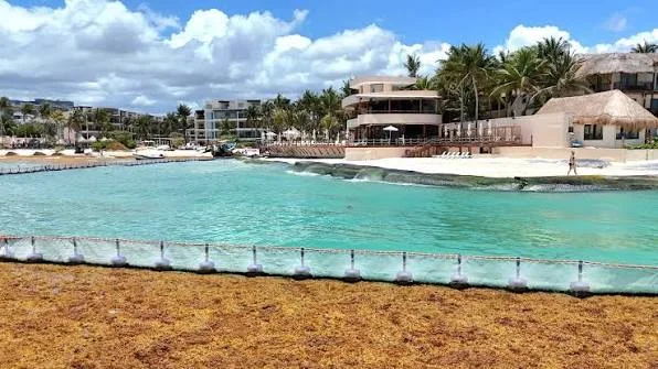
- The first monitoring centre in the Caribbean basin. Opened in 2025 inside the state C5 command centre, using Sentinel-2 imagery to plan the week’s cleaning by beach. It is the first of its kind in Mexico and in the whole basin. Ecoticias
Permanent infrastructure, not a seasonal crew
This is the distinction that matters to an owner. A crew with rakes is a reaction to a bad morning. Vessels, kilometres of barrier and a monitoring system are infrastructure, funded and expanded year over year, and they work before the seaweed lands rather than after. That is why the corridor recovers in days rather than weeks.
- 176,000 tonnes already removed. Quintana Roo has collected more than 176,000 tonnes since 2022, with 222 million pesos, some 12 million dollars, invested in beach cleaning, equipment and marine barriers, and 84,000 tonnes in the last season alone across 2.3 million square metres of beach. Infobae
- A new collection ship. The Navy put an additional sargassum vessel into service alongside the ARM Natans, which the environment ministry said roughly doubles what can be taken out at sea before it lands. Semarnat
- The region is coming here to learn. Cancún hosts Caribbean governments, Brazil and Japan on 1 and 2 October 2026, with Japan interested in contributing specialised collection vessels. El Universal
Monitored by satellite, daily
Quintana Roo runs a state environmental monitoring centre that uses imagery from ten European Space Agency satellites to watch more than 140 beaches, publish daily forecasts and anticipate arrivals before they reach the coast. It is the only centre of its kind in Latin America, and it is why the barriers and vessels are positioned in advance rather than in reaction.
Why the response is strongest here
Because the coast cannot afford otherwise. Tourism is the economy of Quintana Roo, so the beach is not scenery, it is the asset. Compare that with islands in the same belt that face the arrivals with a fraction of the budget and no navy fleet, and you understand why the same seaweed produces very different mornings depending on which coast it lands on.
Geography decides more
than luck does
Sargassum arrives on currents from the open Atlantic, so which way a shoreline faces matters more than which town it belongs to. These are the patterns we see year after year. They are tendencies, not guarantees, and the live map above is what settles any specific week.
Exposed, east facing
Open Caribbean shorelines that take the current head on. This is most of the classic beachfront on the coast, and it is where the daily collection effort is concentrated.
- Tulum’s open beach strip
- Much of Playa del Carmen’s downtown beachfront
- Akumal and the open bays south of Playa
- Mahahual and the Costa Maya
- Daily removal through the season, by state brigades and by the properties themselves
Sheltered or reef protected
A reef, a headland or a bay changes what reaches the sand. It does not make a beach immune, it makes the bad weeks shorter.
- Puerto Morelos, behind its reef
- Parts of Puerto Aventuras inside the marina cove
- Tankah Bay and the pocket bays north of Tulum
- Sections of Playacar where the shoreline turns
- Ask what the beach looked like in July, not in January
West facing and lagoon side
Shorelines that face away from the incoming current are the quietest on the coast for seaweed, and that is a genuine part of their value.
- Cozumel’s west shore, the leeward side of the island
- The lagoon side of Isla Blanca and Costa Mujeres
- Holbox, which sits on the Gulf side of the peninsula
- Bacalar, fresh water, no sargassum at all
- Different water, different swimming, worth seeing before you decide
Where people actually ask:
Cancún, Playa del Carmen, Tulum
The same season reads differently in each town. Check the live map above for the week you care about, then read the pattern here.
Buying in one of these towns? The beachfront guide has prices per square metre and rental rules for each, and the Playa del Carmen city page covers the market that most buyers start with.
This is also why “the Riviera Maya has sargassum” is a useless sentence for a buyer. Two properties fifteen minutes apart can have completely different Julys, and that difference is measurable before you make an offer.
What it costs, and why it
never lands on you
Here is the part that turns the seaweed question from a fear into a line in your spreadsheet. Most of the work on this coast is publicly funded and permanent, and the part that is not is already inside the fee you were quoted before you bought. Nobody calls an owner in August asking for money because the beach needs cleaning.
Per month, against 150 to 300 inland. That gap covers salt-air maintenance, insurance and beach upkeep together, and it is quoted to you before you buy, not after.
The collection work is publicly funded and the building upkeep is inside the fee. No owner on this coast is invoiced in August because the beach needed clearing.
Not a surprise bill. The season is expected, budgeted and worked on daily, and it has been for years. What changes between properties is how exposed the shoreline is, not whether anyone shows up.
Fee ranges are asking-market figures for this coast in US dollars. The public response is the federal strategy announced on 30 July 2026, published by the Presidency. Ask us about a specific building and we bring you its own accounts rather than a range.
The four things owners
actually ask about
Short answers. The long ones are in the building’s own accounts, and we read those with you.
And resale, the question a seller never raises. The buyer who purchases from you in ten years will have more satellite record, a bigger fleet, more barrier and more industry than you have today, not less. What will separate your unit from the one next door is whether your building can produce a cleaning contract, two years of accounts and a reserve fund. All of it inspectable before you buy.
The seaweed already
became an industry here
This is the answer to why Mexico and not somewhere else. Every country the belt touches collects sargassum. Mexico is where it is already being turned into products, and that changes the incentive completely: the seaweed stops being only a cost and becomes raw material that somebody wants collected, quickly and every year.
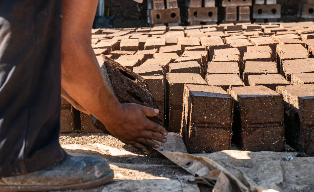
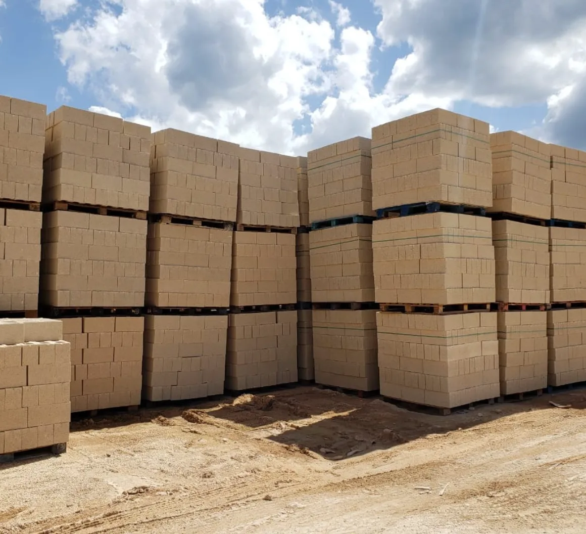
Sargablock, Puerto Morelos
Blocks pressed from dried sargassum, invented by Omar Vázquez Sánchez at Blue Green México. Roughly 40 per cent seaweed, patented, tested by UNAM, and already used to build houses on this coast, donated to families. The model has been exported to the Dominican Republic, Belize and as far as Ghana.
Sargacreto, Playa del Carmen
Treated sargassum mixed into concrete by Grupo Dakatso, for pavers, kerbs, road works, benches and artificial reefs. Each block uses 40 to 45 kilos of seaweed, the material was used on section 5 of the Maya Train, and a plant is planned for Tulum.
Five more uses, already selling
- Paper, pencils and packaging from the fibre
- A leather substitute used in footwear and bags
- Fertiliser and soil improvers, exported to the United States, Ecuador and Colombia
- Biogas and biochar, at pilot and early plant stage
- Cosmetics and nutraceutical extracts, the highest value per tonne
Why that matters to an owner
An industry creates a permanent reason to collect the seaweed fast and completely, including in the years when the news has moved on. None of these uses consumes an entire arrival and none is a silver bullet, but all of them are real, documented and operating between Cancún and Mahahual. The federal plan also funds four handling centres so what is collected reaches these industries instead of landfill.
And the local reason
Every block plant, collection crew and research programme is a job on this coast. A coast that earns from the seaweed defends its beaches better than one that only complains about them, and that is the difference an owner feels in year five, not in week one.
If you have a business plan
for the seaweed, we want to see it
This page exists because we think the seaweed is an industry, not just a season. If you are building something that uses it, blocks, concrete, paper, fertiliser, biogas, cosmetics, collection or drying technology, send us the proposal.
What we bring is the ground: we know where the land is on this coast, what a plant needs in terms of site and permits, who is already operating, and we talk to owners and investors here every week. If your project needs a location, a partner or capital in Quintana Roo, that is the conversation we are useful in.
Straight answers
Is sargassum a reason not to buy beachfront in the Riviera Maya?
For most buyers, no. It is seasonal, it varies by year and by beach, and the collection work along this coast is daily and publicly funded during the season. It is a reason to buy carefully: to check which way the shoreline faces, to look at that specific beach on the live map rather than at a headline, and to underwrite summer rental revenue conservatively. Buyers who look at both February and July before deciding tend to be happy with what they bought.
Which months are worst for sargassum?
In a normal year the heaviest arrivals run from roughly June through August, with the first patches appearing in April or May and conditions easing through the autumn. December to March is typically the clearest stretch, which is also when most buyers visit. Each year is different, so check the live map above for the season you are in rather than relying on an average.
Which beaches get the least sargassum?
As a pattern, shorelines that face away from the incoming Atlantic current: the west shore of Cozumel, the lagoon side of Isla Blanca and Costa Mujeres, and Holbox on the Gulf side of the peninsula. Reef-protected and pocket bays such as Puerto Morelos and Tankah Bay tend to have shorter bad stretches than open east-facing beaches. Bacalar has none at all because it is a fresh-water lagoon. None of these are immune, which is why the live map matters more than the reputation.
Does sargassum affect property values?
Not the way people expect. Beachfront has kept appreciating on this coast through every heavy season so far, including the record years. What does move value is exposure: how the shoreline faces, and how quickly that stretch is cleared. Both are things you can check before you buy rather than discover afterwards, and we check them with you.
Does it affect rental income?
Yes, in the peak months, and mostly through nightly rate and cancellations rather than a completely empty calendar. Summer is already the softer half of the year here. A projection built with the real seasonal curve, higher in winter and softer in summer, is the one worth planning around, and we will build it with you.
Who pays to clean the beach?
Most of it is public. The federal and state response funds collection at sea and on the sand, with the Navy leading it, and municipal brigades work the public beaches. In front of a condominium the property adds its own upkeep, paid from the maintenance fee you are quoted before you buy. It is one of the reasons a beachfront fee runs higher than an inland one, along with salt-air maintenance and insurance.
Is there sargassum in Cancún or Playa del Carmen right now?
That is a question with a live answer, not a general one, which is why the map at the top of this page exists. Open it, click the beach you care about and you see its current condition score and its photographs, updated daily. As a pattern, in a normal year December to March is clear, June to August is heaviest, and the north end of Cancún, the lagoon side and the west shores of Cozumel and Isla Mujeres stay clearest through the season.
Does Cozumel or Isla Mujeres get sargassum?
Far less on their west shores, which face away from the incoming Atlantic current and are the leeward sides of both islands. That is why a day trip to Cozumel is the standard local move on a heavy week, and why west-facing and lagoon-side property is genuinely worth more to some buyers than a first-row unit on an exposed beach.
Is Tulum worse than Playa del Carmen for sargassum?
Tulum’s open beach strip is more exposed: it faces the current with fewer natural breaks, while parts of Playa del Carmen’s shoreline turn and Playacar sits behind a bend. Both are inside the five destinations covered by the federal barrier and collection programme. The honest answer is that the difference between two buildings in the same town is often larger than the difference between the towns, which is why we check the specific beach and the specific building.
What is the sargassum forecast for 2027?
Nobody can promise a season, but two things are known. First, the belt’s biomass has grown since 2018, so heavy years are now normal rather than exceptional. Second, Mexico’s response grows with it: the second stage of the federal plan targets about 4,000 tonnes a day of collection capacity, roughly the average volume that reaches Quintana Roo. For a monthly outlook based on satellite data, the University of South Florida Optical Oceanography Lab publishes one for the whole Caribbean basin.
How reliable is the map on this page?
It comes from Sargazo Watch, an independent monitor that scores about 120 beaches from Isla Contoy and Holbox down to Sian Ka’an, updated daily from visitor photographs and beach cameras. We embed it rather than reproduce it so you always see their current record, and clicking any beach opens their card with the photographs. We do not edit the data and we have no control over the scores, which is exactly why it is worth showing. If you would rather read a scientific source in English, the University of South Florida Optical Oceanography Lab publishes a monthly satellite outlook for the whole Caribbean basin as part of a NOAA-funded programme, and its August 2026 bulletin projected declining amounts in every region through the autumn.
Next: the beachfront property guide, with prices per square metre and the federal maritime zone.

Caribbean water, and a whole coast
working to keep it that way
Public investment is protecting the beaches, while a growing local industry is finding new uses for the seaweed itself.
Tell us your budget and the kind of beach you want, and we’ll come back with the buildings worth your attention, what makes each one work, where the value is, and the numbers behind them.
Buyers who understand this coast make better decisions than those who wait for the perfect headline.

Karina D. Sayed, CPA · CEO, Broker and Owner · Playa Realtors
I have lived on this coast since 2001 and Playa Realtors has represented buyers here since 2008. This page carries the figures the federal government published, the companies actually processing the seaweed and an independent beach map we do not control, because a buyer deciding on a beachfront property deserves the record rather than reassurance.